Webinar: Fast disaster response – satellite technologies for surface displacement monitoring (GEOF)
Section outline
-
An EO4GEO Webinar | July 12th - 14th 2021 from 09:00 -12:00 AM (CET)
The webinar is organized by the University of Zagreb Faculty of Geodesy EO4GEO team in collaboration with Erasmus+ projects GEOBIZ, SEED4NA and UN4DRR.
The participants will get an overview of usage of EO, GNSS and GIS technology in case of catastrophic earthquakes and information which can be gained from those technologies to provide information about the behaviour and displacements caused by the earthquake and providing support to rescue services and delivering information to general population.
The webinar includes theory and practice about InSAR and GNSS technology and targets geo-professionals and researchers who are interested in disaster risk reduction and management of catastrophic events.
Organizer: University of Zagreb Faculty of Geodesy
Language: EnglishTeachers:
- Prof. Željko Bačić, PhD.
- Assist. prof. Danijel Šugar, PhD.
- Marijan Grgić, PhD.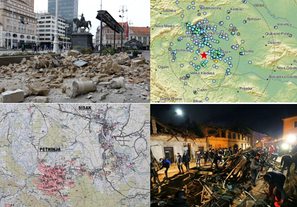
-
Croatia was in year 2020 hit by two devastating earthquakes. First one hit town of Zagreb on March 22nd with a magnitude of 5.5 on Richter scale, and second one on December 29th hit the area of Banija (epicentre near town of Petrinja) with the magnitude of 6.2 on Richter scale. Both earthquakes resulted in severe damages and human losses. Already after Zagreb earthquake a great need for spatial interpretation of the event and its aftermath has been recognized. Therefore, after the earthquake in Petrinja, a quick reaction of geodetic experts followed, using modern satellite and geoinformation (GI) technologies to provide information on the aftermath of the earthquake.
Based on recent experience training has been prepared to share gained experience facing devastating earthquakes which are presenting real threat in many parts of our world and demonstrate usage of EO, GNSS and GIS technology for fast response in case of such disasters.
Training is organized during three days from 09:00 – 12:00 CET daily and theoretical and practical lectures wil be given by Prof. Željko Bačić, Assist. Prof. Danijel Šugar and Researcher Marijan Grgić, PhD from University of Zagreb, Faculty of Geodesy.
-
-
- Introduction, explaining necessity of providing ground displacement information in fast response to the catastrophe and describing technologies which can be used.
- Introduction and basics of InSAR technology: Earth observation systems in support to disaster management, Copernicus program, Sentinel 1 data types and access, satellite interferometry. Hands on InSAR data and processing tool.
- Processing of InSAR data for land displacement monitoring (Guides and steps through Sentinel-1 data processing for place and time, automatization of the processes and interferogram computations). Analysis, interpretation, and visualization of the results
- GNSS (systems, current status, permanent networks, reference systems), methodology (GNSS receivers, error sources). GNSS observation methods, positioning methods, capability. Observation data sources, spatial and temporal frame, observation data types and structure.
- Data processing (online) tool(s). Results analysis, visualization and interpretation of results; comparison of results gathered with other techniques (e.g. InSAR).
- Quality assurance in computation and interpretation process and information dissemination activities. Risks. Conclusion.
-
-
Students mustMark as doneEO4GEO: Fast disaster response: satellite technologies for surface displacement monitoring _ part 1
-
Students mustMark as doneEO4GEO: Fast disaster response: satellite technologies for surface displacement monitoring _ part 2
-
Students mustMark as doneEO4GEO: Fast disaster response: satellite technologies for surface displacement monitoring _ part 3
-